Three Shires Head
Tuesday, 24 April 2018 10:00 AM
Car park at SJ999662. The post code is SK17 0SU (approx)
Three Shires Head is the meeting point between Cheshire, Staffordshire and Derbyshire, whilst Flash is said to be the highest village in Britain. The area has a historical reputation linked with Illegal cock fighting, counterfeit money and general banditry!!
The starting point is a car park at SJ999662 at 10. The post code is SK17 0SU (approx). 8 miles moderate.
Travel Directions
There is a cross country route to the starting point from Macclesfield. However, the simpler route is to take the A523 south from Macc and then turn left along the A54. Follow this road to Allgreave. The road bends to the left and then immediately at the pub turn sharp (hairpin) right on to the minor road which is signposted to Quarnford. Follow this minor road past Burntcliff Top. Immediately after the river the road turns right and then left. Manor Farm is on the right. Immediately past the farm take a hairpin turn on the right down a minor road which is sign posted to Gradbach Scout Camp. The car park is a couple of hundred yards down the road on the right. There are no parking charges.
The route of the walk is as follows:-
Exit the car park at the corner, over a bridge and follow the stream bank to the road, turn right for about 50 yards, and then left at Dane View House/Shiredale. Just before the Shiredale private letter box take the path on the right leading straight ahead. This area can be very muddy. Keep to the right of the wall, and where the wall ends (turns to the left) keep going straight ahead. Go through a gate in a wall straight ahead next to a fallen metal gate. Continue to a green sign (marked 1 on the go4awalk.com plan. Route S107).
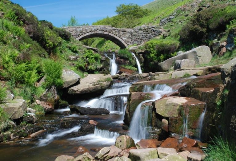
Turn left along the stony track, through a pair of gate posts and then take the footpath marked DVW on the right. Go diagonally up the hillside to reach a clear track. Turn left to follow the track and the River Dane to THREE SHIRES HEAD. (mid morning break)
Turn right up the track on the far side of a stream to a sign pointing to Orchard Common (the go4awalk notes say the sign shows Knotbury but this is not correct). Turn right over the stream up a track which turns left towards the end. Follow this to a minor road. Turn right down the road past Knotbury Lea Cottage and south to a T junction.
At the junction turn left and then half right over a small stone footbridge. Follow the footpath up the moorland to reach Wolf Edge. Continue in the same direction down the other side heading towards some buildings in the mid distance which are surrounded by trees. (stop around here for lunch). Turn left up a track heading towards a pair of chimney stacks which can be seen on the skyline. Follow the track to the village of FLASH. (The go4awalk notes include a detour up Oliver Hill which I have omitted.) Turn left at the minor road and go down past a chapel to the church at the junction.
Turn sharp right at the church and follow the road to Lower House Farm on the left. (Take a photo at the sign marking the village boundary) At the farm go through a small gate down some steep steps and across the field to Flash Brook Farm. Turn left at the stream and cross by the footbridge. Follow the path up the hill, which can be the last climb on the walk. Near the top of the wall, either:-
Turn half right up to the top of Ann Roach Rocks, which has a pole at the top. Then continue in the same direction, across a path and through fields to reach a minor road in front of trees, or Go to the left of the hill, round it to a farm (Alders Green?) then to the minor road in front of the trees.
Turn right on the minor road, passing Gib Torr Rocks on the left. Continue along the road, past Moss Top farm, across a junction to another road. On the right there is a blue sign warning of a narrow bridge. At this point go straight ahead following a rough track up a small hill, through a gate and onto open fields. Follow the track with cliffs and some boulders in the middle distance on the right. On the left arrive at some places where stones and rocks have been stored, and join a farm track which descends through a stoneyard to Gradbach Farm. At the farm follow the signed footpath, half left. Then turn right on the minor road, past Gradbach Scout Camp and the waterworks gates back to the car park.
Action
Please confirm if you are able to join us for the day & if you wish to car share. If you have friends / colleagues / associates who would like to walk with us please pass on the information.
If you give John Thompson your home location (
Bad Weather
Should the weather forecast on the previous day seem to be very bad for our walk please ring to confirm if the walk is still on?
All Dates
- Tuesday, 24 April 2018 10:00 AM
Powered by iCagenda
Please check alert message.
Site designed by: Enterprize Web Design & Print Ltd | ewdp.co.uk